


Charleston's peninsula could become a walled city again for the first time in centuries if the results of a flooding protection study released Monday come to full fruition.
The preliminary plan — the results of 18 months of work by the Army Corps of Engineers — is the preferred path forward of seven different options the Corps considered. It would encircle much of the peninsula with a wall running almost 8 miles to keep out hurricane surge.
Gates would let water run into the marshes and two rivers that bound Charleston.
Five new pump stations would aim to avoid a "bathtub effect" and move rainfall out of the perimeter. A breakwater slightly offshore of the peninsula's southern tip would be designed to slow down damaging waves.
That, and efforts to flood-proof a few structures outside the barrier, come to an unprecedented total for a flooding project in Charleston: $1.75 billion.
The city of Charleston would have to cobble together some $600 million of that bill, or 2½ times more than its entire budget this year.
Mayor John Tecklenburg touted the plan as the first instance of "meaningful federal participation" in dealing with sea level rise, an existential threat to the 350-year-old city. The Army Corps plan, which will be refined with public input over the next year, isn't guaranteed to get federal funding, but lays out a roadmap for a future appropriation by Congress.
"If you even want to have the opportunity to prosper for another 350 years, even another 100 years, I believe you have got to look at the reality of doing something like this," Tecklenburg said.
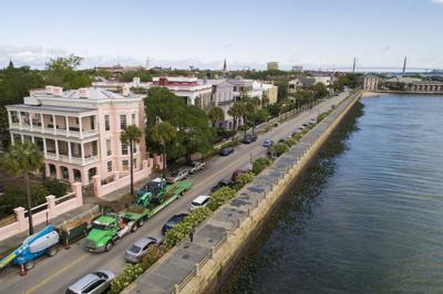
The path of the flood wall would start at a point along Interstate 26 north of Wagener Terrace, continue south along the Ashley River, wrap around the peninsula's southern tip on the current path of the Battery sea wall, follow north along the Cooper River, up Morrison Drive, stopping approximately at Mount Pleasant Street.

A graphic showing the tentative path of a flood protection wall around the Charleston peninsula, in yellow. The exact path may change. Provided/Army Corps of Engineers
The barrier would sit about 3 feet above the current height of the High Battery, or roughly 8 feet above where minor tidal flooding begins, according to the Corps' report. Because of elevation changes on the ground, it could appear taller in some places and shorter in others.
It is designed to protect the city from storm surge — the wall of water pushed onto land by a hurricane.
"This is the one risk that could do the most damage to the city in terms of property damage and risk to life, as well," said Mark Wilbert, chief resilience officer for the city of Charleston.
Plan authors say it will also benefit the city in now-routine, sunny-day flooding fueled by sea level rise. Higher tides that regularly swamp low-lying parts of the city are projected to become an every-other-day reality by 2045.
Already, the city has passed a grim milestone for tidal flooding: there was at least a minor swamping for 89 days last year.
It's unclear how people on both sides of the proposed wall will receive the plan. The study's release Monday opens a 60-day comment period for the public to weigh in.

“This is what we’re really working hard at: how do you blend that wall in so it complements Charleston?” Wilbert said. “That’s the phase we’re in right now.”
Winslow Hastie of Historic Charleston Foundation and Laura Cantral of the Coastal Conservation League urged the comment period should be doubled so residents can absorb the enormity of the plan.
One big question mark is precisely how the wall would look or what materials it would be made of, something that will be refined in the next year of discussions, Wilbert said.
Aesthetics will likely weigh heavily for many in a city where changing the paint color of a historic home is subject to extensive board review. But any additional features beyond the Corps' baseline design would not be paid for by the federal government.
Regardless of its composition, the barrier will inevitably change the low-lying city's relationship to the water around it. Tecklenburg said that the project presents an opportunity to create a pedestrian path along the wall, similar to the current High Battery.

Construction workers walk along a new portion of wall on the Low Battery on Murray Boulevard on Monday, April 20, 2020. If a higher wall proposed by the Army Corps comes to fruition, it could be built on top of the renovated Low Battery. Lauren Petracca/Staff
How it works
The wall's height is essentially the tallest it could be without costs ballooning exponentially; any higher, and it would require lifting the Ashley River Bridge or creating a gate across it.
The walls would need support from pilings 50- to 70-feet deep into Charleston's underground marl, in part, to keep them stable in the case of an earthquake.
There will inevitably be properties in the way of construction, too. Charleston would be responsible for acquiring any land needed for the work. It's unclear how many properties will be affected, but the Army Corps estimates the federal government might have to pay almost $5 million toward relocation costs for 18 affected parcels.
Outside the wall, the picture is less clear. Not protected are S.C. Ports Authority facilities on the east side of the peninsula, Magnolia Cemetery, several industrial sites and some breweries. Also unprotected is the tiny Rosemont community, one of a few places where the Army Corps' graphics indicate it will pursue "non-structural" measures.
That may mean house relocations, floodproofing, elevations or even buyouts. About 100 structures could be altered this way, in Rosemont and elsewhere.

Beyond construction, the new infrastructure would require carefully orchestrated operation. City staff would need to learn how and when to turn on the pumps and close the gates in the wall, designed to let rainwater drain and block tides from seeping in.
The Army Corps and city staff took a trip last year to New Orleans to learn about how a separate state agency operates that city's complex system of levees. While it might require forming a team of city staff, Wilbert said, the operation would not be "anywhere near the size or complexity it was in New Orleans."
The Army Corps suggests closing the gates around the Holy City when an 8-foot tide is predicted, or the point at which the National Weather Service says major flooding begins.
The five pump stations would be located just north of the Ravenel Bridge entrance on Morrison Drive, off of Murray Boulevard by Lenwood Boulevard, by the Medical University of South Carolina Ashley River Tower, in the marshland north of the Charleston RiverDogs' stadium and in the marshland north of Gordon Street in the Wagener Terrace neighborhood.

High tide floods park benches near Lockwood Boulevard on Feb. 20, 2019, in Charleston. The National Weather Service office in Charleston reports that, from Nov. 13 to Nov. 19, at least one high tide each day crested above 7 feet. File/Andrew J. Whitaker/Staff
Finding the money
City officials estimated in 2017 that fixing all of the Holy City's flooding issues, from the outer suburbs to the historic center, would come to $2 billion.
It has embarked on several efforts already, installing valves to stop the tides from seeping up through pipes; digging a network of drainage tunnels downtown; buying out repeatedly flooded homes; studying several sections of the city in the Dutch Dialogues plan and implementing strict building rules in the outer West Ashley suburbs along Church Creek.
But, in cost, none of those works approach the total of the Corps' plan, or even the city's 35 percent contribution of roughly $600 million.
Tecklenburg urged that the city wouldn't need all that cash at once, especially if the project is done in phases.
"I think of Lockwood and West Edge area, I think of the East Side," Tecklenburg said. "There's a few areas if you just did a portion of the perimeter and get some more immediate benefit and then some other areas the berm doesn't need to be as high because elevation is already higher."

It's been challenging in the past for Charleston to gin up monetary support for flood projects, particularly at the state level. A $10 million ask to connect the often-swamped Medical District to drainage elsewhere in the city was recently rejected by state lawmakers writing South Carolina's budget.
And even the federal contribution isn't assured, but if the Corps' plan finds purchase in town, it could end up as a shovel-ready plan for when the next disaster strikes.
"We’re probably going to have to have another big hurricane, and then all of a sudden there's going to be maybe a greater sense of urgency," said Hastie, the chief executive officer of Historic Charleston Foundation. "Without that, it’s challenging for Charleston to raise that money, no question."


